Saturday 15 February 2014

Day6: Leh Manali

Rohtang Tunnel

A 2km altitude drop. Manali feels warm. The road blurs away as I tried to trace it.

Ride along river Chenab which has Baralachha la as its source
The last big climb of my ride was on the most famous pass of this route: Rohtang Pass. The one that usually results in the closing of the road. The Rohtang Tunnel Project had started some years back and is almost nearing completion and probably would be ready by 2015. Tandi to Manali was a warm ride with snowline floating on the top as I rode in the valley. Ascending to the Rohtang was the dirt riding experience. Lots of slush and traffic as well. The cars that went splashing the mud overtook me but only ended up in getting enqued in the longest traffic jam I witnessed in my ride ( or may be in my life). Signs of civilization now form a continuum.


The 4km long traffic jam at rohtang. 2-wheelers could flow through the gaps but not as quick as...

Prevention! 

The downhill was too smooth and fast. Stop, take a snap.

Pleasing green


The Leh Manali stretch was complete. I was satisfied with the ride so far and yet wished that India was a bit more longer. Having missed out on Chandra Tal, Tso Moriri and Tso Kar, I have a reason (though not required) to come back sometime and ride again. Staying in north Manali away from the town was a good choice to make. The orchards are pretty. Solang is close by where I intended to trek though didn't. The night at Manali I saw light trails like a slingy. There was heavy traffic trying to cross the Rohtang at night. There are some diversions but most of these tourists vehicles do not reach beyond Keylong. The route was far less crowded. During the mornings, the traffic jam is again a long one. Probably longer than 4kms. Most of these tourists try to reach Solang/Rohtang and enjoy as:
bhasad, as is Solang

The ride from Manali to Pandoh to Chandigarh to New Delhi was a test of temparament. Chandigarh was a pleasant stay with some city touring: Sukhna Lake, war memorial and parks and the university.
Riding had become tough. It was the hot month of June while I was aclimatized for the snowy weather. The traffic felt annoying and I just pedalled hard to reach the capital on 12 June 2013 and felt satisfied with my entire ride.

Thursday 13 February 2014

Day5: Leh Manali

approaching Baralachha La(4890m)


Baralachhala: A wide pass and the final pass on this ride close to 5000m.

Just as I was reaching Sarchu, the valley widened and it looked as if it were to be green then onwards. But just after Sarchu, begins the climb for the final high altitude pass: Baralachha La and the greenery is lost again. But the pass still looks wide and ideal for a snow scooter/ ski. But I had a late start and a flat tyre mid way which made me retire at night around 9. A dark ride.

 The road to and from passes convert to streams during the day time which aren't much of a problem during the day but early mornings when it is difficult to differentiate from ice. The usual 4 wheelers o slow and avoid braking but that trick doesn't help much. Instead one must try and ride perpendicular to the ground with low saddle height.


 Snow on the passes to the south is far more than the ones up north during the early monsoon. These are the earlier passes which the monsoon clouds meet and hence, Rohtang and Baralachha La are the ones that shut of the Leh Manali route. It might turnout to be a different story during the winters.


I expected the ride to be easy after the Baralachha La as the road seemed in good condition and a down hill

Suraj Taal: A broken frozen lake

The ride seemed to speed up and ease up. The Suraj Taal was new stuff to watch. The route had many newly open parachute shelters and anyone on this route(even cyclists) can safely rely on them. They come up as the passes open up.
The melting ice comes down through channels and waterfalls that cut across the road. It was tough riding through such streams on a bullet long back but on the cycle it was a different challenge altogether. The moment cycle entered a deep pit and stopped, it meant a stream bath. The first few I witnessed, I crossed them barefoot trying to keep the feet dry for the rest of the journey but as I realised that this took up a lot of time and the next habitable place was not so near, I started adapting a new skill in riding.
Another such stream:

The flow drops by evening. But the water melting away at this rate also accounted for bigger rivers and valleys. Tree line soon appeared and the smell of shrubs was strong and yet pleasing.
Village Dharcha

River Barai Kade. From such heights riding downhill at a high speed felt like being in a helicopter

Trees look wonderful


Felt great to look down upon human civilisations :P

Keylong was a big town on this route with wider roads and I revised my target to o for Tandi which was only some kms away but it grew dark and then I turned slow. Failed to search my headlamp in the bag at night which further slowed me down.Chenab was then running besides me and the roads were completely deserted. I turned out to be extremely slow in the dark and it did look scary. I finally found some light and shelter thereafter at night around 9.
 This ride was a long one in terms of hours, kms, events and one of the risky ones. The rides on this route had been most eventful and throughout I had been closer to nature though at certain places I was bound by the road. There were rides I wanted to hike, peaks I wanted to scale, detour for hidden lakes but the passes always lure for the hidden valleys. The exploration would continue in later trips. There is a lot I got to see and feel closely and there remains a lot as well.

Tuesday 11 February 2014

Day4: Leh Manali

Pang to Sarchu
This ride included two 5000m passes to be crossed... this sounds tough but the passes are close enough and not much altitude is lost in between. After the first pass, Lachulung la( various other names: Lachung La, Lachalang La), I encountered the first major technical problem on the bike. The rear wheel gained a degree of freedom. It started wobbling. I found that it was lose so removed it and checked. All seemed to be good but soon started wobbling again. I tried to see if the frame had deformed( though unlikely), but that wasn't the case. Replaced the axle but that didn't help. It was the wheel that was sliding on the axle and the nut that needed to be tightened was a large one. After this realisation, I didn't have to worry much. If it had one bad, I would have got assistance from some trucks moving south. But now I was stoppin the bikes to have a look at their tool kit. In between the Lachulung la and Naki La (the second high pass of this day's ride: 4922m by myGPS), their is fortunately a suitable place for setting up parachute restaurant and fortunately I found a large team of riders with a support vehicle. Here I would get the tools and when I did, I found that the nut could be comfortably tightened by hand.
Just a small jump across NakiLa were the Gata Loops. The meandering river was again in sight during the descent. After the loops was a long traffic jam. The Whiskey Bridge was undergoing construction ( Bridges here are almost reconstructed every year and this was at the start of the season. 3 bridges named: whiskey, brandy and twing twing).fortunately in between, I could carry my partner and run across. Had I been a little more fast, I would have been the first person in my direction to reach Sarchu but who cares about speed ;)
A flat and broad valley. The greenery felt pleasing and one can understand why Army personnel complain of the beautiful deserts.


 Among the many shots are some of the self taken pics which were at times hard to take but fun. On this ride I missed out on a pic of fighting marmots. Would like to watch them some time.
Frozen fall


from Lachulung La

A peak I wish to climb, seen after Lachulung La

at Naki La

Descent just after Naki La. Gata Loops start some distance later.

Meandering River and a small fragment of Gata Loops

Introducing Green

Night Shot

It was getting dark while I reached and this place was perhaps as cold as Pang (one of the coldest feels). The sky was clear and got some good shots at night.

Sunday 26 January 2014

Day2: Leh Manali

Having crossed the 5000m altitude mark 7 times by now, there was considerable confidence of crossing over Tanglangla. Claimed to be the 2nd highest(3rd according to my GPS) motor-able pass. The BRO had built a runway on the hills. The climb was a long one with only short patches that were bad. It was a  good broad road with snow on the sides as I moved higher. I was fortunate to have a glimpse of the Himalayan Pica (a cute rodent) which I later managed to capture (persistence).
The road makers were finally found at the pass.
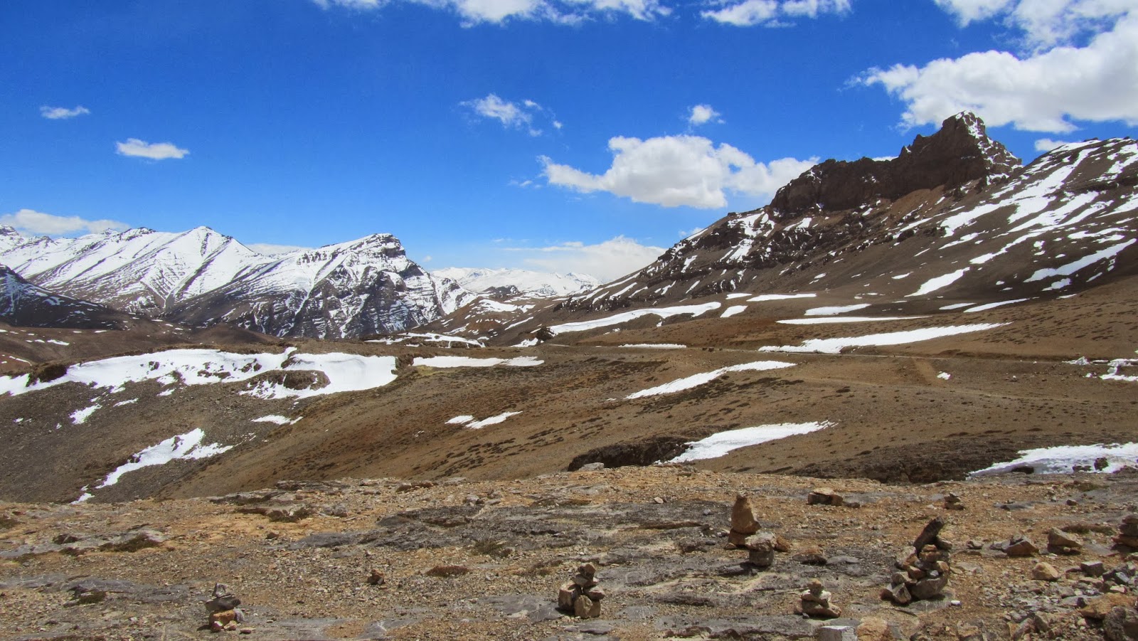
On the climb to Tanglangla

Road to heaven! Hats off BRO

Himalayan Pica
 The descent from Tanglang la was not as
comfortable. It was practically a bumpy slush ride and the road dried up to dust as I reached a terrain relatively plain but with a punctured tire. Not having used the new tire that I carried all along, I decided to put it on to avoid the cleaning part during the puncture. I was nearing morey plains and water was a precious resource now that shouldn't be wasted. After plenty of rough riding on miserable terrain this was the first flat in this state... the tube had given up.
Not much climb was what I assumed and overall some more descent to Pang. That was correct and this ride seemed to be more pictursque than any before. It was one of the riding days with most number of snaps taken. Now came the morey plains which I had been warned about for shortage of water. Apart from enjoying the terrain and wondering why this was so inhabited, there was a major question that I had to answer. How to survive here? It was an important one. The terrain was flat, the road was good and I had less than 50 kms to cover to find Human company but then there was the terrible headwind.there was no escaping and every now and then, I considered a plan-B of setting on under some rock. Water would not be a problem. There was snow and some puddles were observable at my service. I had let Tso kar pass which was an offroute. Should I have visited there and tried out my survival near a lake? The most reliable thing to do was to pedal hard even if it got dark. I did not expect the wind to reduce at nights.
But these natural threats are always welcomed when the views are pleasing:
towards one end of the morey plains, one can find shrubs, sheeps&yaks, shepherds

The Morey Plains

One such puddle that gave me considerable confidence
While the pedaling continued, it was about to get dark, I came across a view to my left.. It was a gorge. Can't do the justice to the view with my snaps but they reveal more than the words. Here's the pic:
The gorge was pleasing. The hills to my right reduced in height and I saw the sun. It grew a bit brighter here. There was water and a gorge is suitable for survival. But looking down and following the river I got the relief. Below was Pang. It was a small downhill and I reached the bottom. I was no longer tired and granted myself a holiday for exploring the gorge. It was exciting to stay up at night and catch some glance of the gorge but it was too cold. Not that I wasn't out.
Following day(day3) I walked up the river. Though I didn't seem to move quite far and that aspiration remains to trek further to the end of this river. Probably they are the mountains at the horizon. Apart from the wild asses and some birds, I saw the humans(locals) on my return to Pang
There is pleanty of room(warm tent cum restaurant) to stay and most of the tourists put up here. Some motorists after meeting the challenges on the route from Manali to Pang get so determined to reach Leh(>200kms) that they take up the ride even in the dark which seems more of an escape. Roads on passes could be icy at night and this stetch is one of the most picturesque.

Wednesday 22 January 2014

Day1: Leh-Manali

Karu-->Rumtse
Karu(around 40km after Leh on way to manali)
Ride to Rumtse is a short one and I got to see great roads being constructed by the ever hardworking BRO. Upshi comes on the way where one can decide to go to Tso Moriri. I always had that in my plan but towards the end had procrastinated it for a next trip. The terrain in Ladakh is ever changing. Initially reminded me of the sharp and brittle Stok Kangri region and very soon it changed to rounded hills. Crossed by a Pashmina goat farm and some villages. One can find plenty of places to put up in Rumtse but most bikers targetting from Manali or Leh often skip this place as it is too close to Leh for them to halt.
There is a monastery as well worth visiting.
Chukar: a common bird in the region

Village farms on the way to Rumtse

Reminds me of Stok Kangri(first place where I saw such eroded terrain)


Pashmina farm near Upshi

Hiked up a pass and was surprised to find some signs of habitation